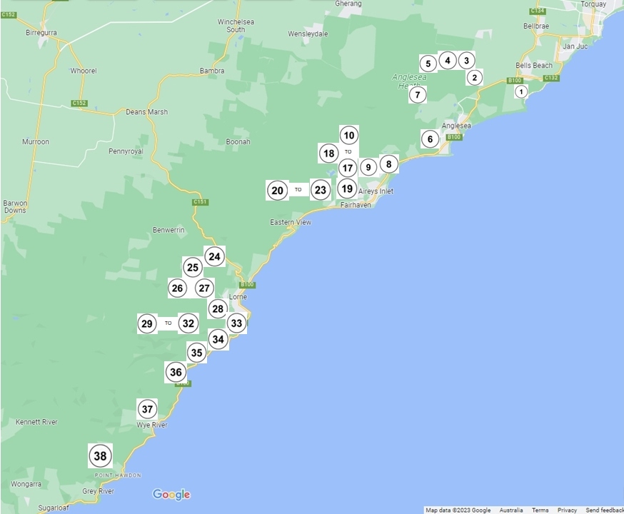
Map legend – list of walks
Walk 2: Anglesea Heathland – Shiney Eye Circuit
Walk 3: Woodland Track off Forest Road
Walk 4: Harrison Track
Walk 5: Haggarts-Allardyce Tracks
Walk 6: Springtime Wildflower Experience
Walk 7: Yan Wirring Mirr Loop
Anglesea Perimeter Walk
Walk 9: Ted’s Ridge Track
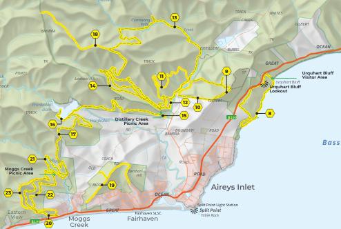
Walk 10: Distillery Creek – Ted’s Ridge Track Circuit
Walk 11: Aireys Inlet Woodland Circuit
Walk 12: Distillery Creek Nature Trail
Walk 13: Currawong Falls
Walk 14: Ironbark Gorge
Walk 15: Distillery Creek Ephemeral Wetlands
Walk 16: Distillery Creek to Painkalac Dam
Walk 17: Distillery Creek to Moggs Creek
Walk 18: Loves Track
Walk 21: Moggs Creek Circuit Trail
Walk 22: Moggs Creek Ocean View Walk
Walk 23: Moggs Creek – Coalmine Creek
Walk 25: Erskine Falls
Walk 26: Lemonade Creek Track
Walk 27: Cora Lynn Cascades
Walk 28: Allenvale to Phantom Falls
Walk 29: Sheoak Picnic Ground Nature Walk
Walk 30: Sheoak Picnic Ground – The Canyon
Walk 31: Sheoak Falls – Castle Rock
Walk 32: Kalimna Falls
Walk 33: Ocean Walk – St George River
Walk 34: Sheoak Falls – Swallow Cave
Walk 35: Cumberland River – Jebbs Pool
More detailed maps can be found at the bottom of this page.
You can also purchase a full colour booklet containing detailed track notes for each of the walks plus a map of all the walks from Great Escape Books in Aireys Inlet, the Anglesea News & Lotto, the Angair website or by sending us a message on the Contact Us page.
Time and distance
![]() Times are given for completing each walk at an unhurried pace. Additional time needs to be added to allow some time to enjoy scenery, vegetation and perhaps fauna along the way.
Times are given for completing each walk at an unhurried pace. Additional time needs to be added to allow some time to enjoy scenery, vegetation and perhaps fauna along the way.
Access
 This describes the specific starting place and suggested parking area for each walk. One way walks are best done with a ‘car shuttle’ – leave a car at the pick-up point and then drive to the start of the walk leaving this car to be picked up later.
Level of difficulty
![]() Generally the walks are divided into easy, moderate and difficult. Additional information is provided for some walks.
Generally the walks are divided into easy, moderate and difficult. Additional information is provided for some walks.
Easy – A leisurely walk on level or undulating terrain.
Moderate – The walk may involve uphill or downhill sections or crossing of water by way of rocks.
Difficult – The walk may include rough terrain, long steep ascents or descents, or more difficult water crossings.
Walks around Anglesea


Walks around Anglesea – Fairhaven


")
Walks around Moggs Creek


")

Walks around Lorne to Cumberland River


Walks Jamieson to Grey River


Dogs ON-LEAD in the national park
- Walk 33: Ocean Walk – St George River
- Walk 1: Ironbark Basin Nature Trail
- Southside Beach, Addiscott Beach, Point Addis to Anglesea via beach and Surf Coast Walk
- The beach between Urquharts Bluff and O’Donohues Beach access
- Walk 14: Ironbark Gorge including Distillery Creek Picnic Ground
- Walk 19: Fairhaven-Moggs Creek Ridge
- Walk 22: Moggs Creek Ocean View Walk including Moggs Creek Picnic Ground
- Lake Elizabeth Camping Area and the Lake Elizabeth Day Visitor Area and its walking tracks
- Johanna Beach
- Many parts of the Otway Forest Park
Map of the walks
Click on map to enlarge (pinch fingers apart to adjust zoom on phones)
Walks around Anglesea, Aireys Inlet, Fairhaven and Moggs Creek

Walks around Aireys Inlet
Walks from Lorne to Grey River
